PART 1 - THE WIDER LANDSCAPE
"Otterton, a pretty fisher town,
standeth on the east side of the haven.
About a mile from Ottermouth,
and on the west side is Budleigh."
Leyland, 1542
Background and context
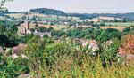
The basis for the settlement was the Otter, a meandering lowland river, its flood plains once a traditional water meadow landscape now criss-crossed with drainage ditches. Framed by tall red sandstone cliffs its estuary mouth, a salt marsh since the build-up of a shingle bar in the 15 th century. To the west (outside the parish) lie the commons of Bicton, Woodbury and Colaton Raleigh, heathland overlying infertile pebble beds. To the east rise undulating greensand ridges, overlaid with clay and flint, characterised by larger fields, enclosed by a network of hedgerows and mature trees. This remains estate land, which has a parkland appearance as it slopes down to the River Otter below.
Today
The village yet retains a rural feel. The effect of fields and former orchards reaching down into the village is to divide the built environment and give glimpses of the surrounding countryside. Views into the landscape reinforce the rural character of the village and are very important to the character of Otterton as each of them retains something of the settlement's heritage. Chestnut trees are a feature of the Green, rough grazing of the Glebe Field, the apple trees in the Orchard and aged yew trees in the church yard - precious links with our past. Indeed, for the overwhelming majority of people (over nine out of ten) the fact that views from the village are mostly rural with few manmade features is considered to be important or indeed very important.
Relevant Local Plan Policy: EN1 (Development in Areas of Outstanding Natural Beauty)
Design Principles for Otterton:
1. The open green spaces on the periphery of or rising up from the village, that define its character, be retained, safeguarded from development and, where possible, enhanced. (In particular, land of amenity status i.e. the Glebe Field (Eatcombe Field) and also Anchoring Hill).