PART 2 - THE SHAPE OF THE SETTLEMENT
"On the opposite side of the Otter river is
Otterton, a village grouped around a knoll
on which stands a modern church."
J.H. Wade, `Rambles in Devon', 1930
Background and context
Otterton was established as a valley settlement at a river crossing point (typical of the area). A nucleated settlement that has developed along the contours of a tributary valley running into the larger Otter Valley, a brook running in season along its length. Almost certainly established by the Saxons, who introduced an open field system, large fields of narrow open strips bounded by earth banks planted with hedgerows, (`Devon banks') - the latter, still a characteristic feature today.
From the 13th century enclosure of these strips gave rise to the narrow hedged plots, or `closes', appearing on older maps of Otterton. These too are still evident today as the thin, but relatively long, gardens rising up from Fore Street and in other parts of the village. The shape of the settlement confined and accessed by narrow lanes that originate from the early middle ages, again typical of the East Devon area.
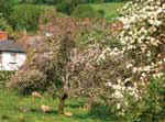
Each field, its own name, each farm its own orchard, the effect was, and still is, to create a vegetated and wooded effect.
'The Orchard' still resonate to Otterton's past. Retaining such open space protects the village's rural character while linking it with the wider countryside beyond.
Today
Latterly, the shape and nature of parts of the village has been altered. Early 20 th century development in Fore Street, Behind Hayes and Lea Road (formerly Pig Street) have been followed by significant post war development in more recent years.
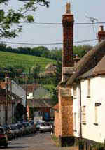
Traffic growth has also had an impact on the feel of the settlement. Once quiet streets are now busy with the passage of increasing volumes of traffic which nearly nine out of ten feel has had a detrimental impact on the village (though traffic calming is not widely regarded as a solution). Nonetheless, Otterton still retains narrow lanes that as yet remain largely unspoilt - their Devon banks and old walls, or passages worn through red sandstone are tangible links with the past and an inspiration for the future.
Ottery Street. The importance of green space is again highlighted.
Otterton has evolved over time, its shape defined by green spaces, traditional narrow lanes, trees and hedgerows, all of which combine to create a diverse patchwork. The retention of such features and the avoidance of further development in large clusters are considered important or very important by almost nine out of ten inhabitants.
| Relevant Local Plan Policies: |
|
S2 (Built-up Area Boundaries for villages) |
| S3 (Development within Built-up Area Boundaries) |
| EN5 (Land of Local Amenity Importance) |
| EN16 (Preservation and enhancement of Conservation Areas) |
| EN17 (Demolition of Unlisted buildings in Conservation Areas) |
| EN26 (River and Coastal Flooding) |
Design principles for Otterton:
2. Future development should avoid the skyline and not dominate the village.
3. Large cluster single design development should be avoided.
4. The green open spaces within the village that define its character be retained,
safeguarded and where appropriate enhanced. (In particular land of amenity status i.e.The Green and The Orchard).5. Retention of existing, and provision of new planting using native species should form an integral part of any future development proposals.
6. Protection, enhancement and creation of traditional features including lanes, walls and boundaries, (Devon banks) to form an integral part of any future development proposals.